The title announces Arnhem, the Dutch city where, seventy years ago today, the "Red Devils" of the 1st Airborne Division is slowly being ground down in close combat with 9th and 10th SS Armoured Divisions of II SS Armoured Corps, last encountered in its massive train convoy attempting a Frederican grand operational manoeuvre across the continent of Europe to counterattack and drive the Allies into the sea before the Russians notice that they are gone. The months intervening have not been kind to II SS Armoured Corps. They are currently taking out their frustrations on 1st Airborne.
The title lies: I am talking about XXX Corps' advance down a road, specifically, "Hell's Highway," the old Route 69, now Netherlands Motorway A50, and the post that this one looks back on is rather this very considerable "Technical Appendix." You may or may not notice that I cleaned up some typos this morning, but I also added a video to that post. And also here, so that Faye Wong can help us keep our feet on the dharma-path. (Remember that wisdom is like an orange. You cannot have juice unless you squeeze it.)
There's a cooler in one corner of the meat department at my store for pickles. You would think that the point of pickles is that they're shelf stable, but, no, these are European-style pickles, which is to say, very fancy, and obviously fancy pickles need to be refrigerated even before the seal is broken.

If Northern Europe is a pickle, and, in general, having spent the last week on vacation in backwoods Canada, I am inclined to see shriveled old things everywhere,* it is a very fancy pickle. The picture above is a stock photo of an animal overpass on the A50 Motorway between Eindhoven and Nijmegen in the state of North Brabant in the Kingdom of the Netherlands (the Country Formerly Known as the Seven United Netherlands, and never called "Holland.")
The overpass was inspired by older ones in Banff National Park, one province over from my natal British Columbia, which in turn is intended to persuade the local moose to use the overpass instead of wandering across the highway by putting a bit of green in their way. The Dutch, desirous of further encouraging the reviving wildlife of North Brabant, took the basic idea and turned it up to 11. Which is to say, it's not really the overt character of the technology that is the joke here. You're going to have to look at the subtext. Initially, the subtext is that there's a major nature preserve straddling a major motorway in the most heavily populated (large) country on Earth. The A50, everyone:

Or, to see it another way,

This is kind of a weird perspective. A route map of a highway that puts it obliquely to the centre of the map? At this point it will probably occur to you that I am going to argue that the A50 is special in some way, and attempt to make the point that one of the criticisms of OPERATION MARKET GARDEN,that XXX Corps was directed to relieve 1st Airborne on a single roadbound axis of advance is not really fair.
And there's your point. Talking about roads in northwest Europe, I argued that a major cultural and religious frontier owed far more to the lack of nearby gravel than to the cliched obstacles of mountain and jungle. 17,000 tons of crushed rock for 76 miles of road, between 4 and 5000 tons per mile, defines the limit of traditional roadbuilding. The cost of building a permanent way in the old-fashioned style, with a bed of crushed rock on a well-drained foundation of compacted soil, will rise exponentially with distance from a gravel pit, or, as proxy, from a riverhead with access to gravel pits. As Dutch military historian Cornelis Schulten pointed out in an Arnhem retrospective published a few years ago [citation needed], the reason that the A50 is the only route up which XXX Corps can advance is that the road was laid through one of these gravel-pit deserts.
It is not, of course, that this was in any way a mystery. The original Highway 69 was built, at great expense, precisely to link a series of major river crossings. Long before waterbound macadam roads, the traditional track reached Nijmegen on a clay ridge that snaked between the major water courses on the sandy bottom of the North Brabant landscape because it is on the boundary between them. It is a natural geological formation, a levee between the limits of two floodplains, and the existence of a Roman fort at Nijmegen shows just how long it has been used as a route. Even paved, it is none-too satisfactory, as the roadbed tends to "float" on the clay. The new A50 is a triumph of civil engineering.

I am not entirely clear what Bamtec is laying here, but it is clearly a great deal more fancy than asphalt-on-concrete-on-gravel-on-packed earth. None of this is available to Horrocks and XXX Corps, of course. What he has is 9000 engineers, 2000 tons of bridging sections, and a great many trucks which can only advance up the A 50 if tanks and infantry are not using it. Bearing in mind that a 20 foot road is supposed to support a division, not a corps, and you can well imagine the kind of congestion that is going to be dismissed by a certain breed of writer as British soldiers taking tea breaks. (It's hilarious because British people like to drink tea! And take breaks!) Nijmegen is just below where the Rhine's main distributary, the Waal, breaks off,

Arnhem is on a much smaller arm of the river, the Lower Rhine, and, indeed, just below the IJssel branching. Here's some maps.


Hey, there's the Kleve of "Anne of Cleves!" Now you know a little more about Henry VIII. This isn't the best map of the region for turning geography into history. If you can track down a copy of the atlas volume of Vault and Pelet's French official history of the War of the Spanish Succession, their multi-page map of the Rhine will allow you to understand the whole "Juelich-Berg" thing. Maybe. If anything can.
However, what we can understand from this map is that it is not some horrible historical accident that II SS Armoured Corps was in Arnhem waiting for the paratroopers. Look at the way that the floodplain is gathered in by Arnhem's hills, and you will instantly appreciate that the Germans would have been crazy not to put a garrison in the city.
MARKET GARDEN was a pursuit operation. In "pursuits," attackers chase the defeated enemy, while the enemy tries to get barriers, such as, for example, rivers, between them and the pursuers so that they can stop and reorganise themselves. Pursuit and exploitation forces, for their part, attempt to capture defiles through these barriers, such as river crossings, before the defender can organise their defences. So, as the defender, you look at the map, and you ask yourself, "Where is the enemy obviously going to try a coup de main?" MARKET GARDEN was a masterpiece of planning and organisation compared with STAVKA's attempt to vault the Dniepr, and pure genius compared with Operation NIWI, which actually delayed the German advance by preventing a Belgian company from retreating on schedule.
Failures, and I have singled out failures, do not mean that coups de main are mistakes. At their worst, they force the enemy to disperse their forces. (You do not hear very much about the German forces sitting in Emerich on Sept 23, 1944, but I assume they were there.) At their best, they obviate the need for a difficult siege. In the case of MARKET GARDEN, Allied success at Arnhem would have led them to the Zuider Zee, cutting off the entire Hook of Holland. Fifteenth Army in the Scheldt estuary would have been cut off, and Rotterdam would have followed Antwerp into the bag. Britain would have been out of range of V2s, and in the unthinkable event of fighting in the summer of 1945, the Dutch Class of 1926 would have been available to the Allies.
So Arnhem was worth trying, and, in the cosmic scheme of things, 1st Airborne Division was dispensable.
So much, then, for that. Back to the road. I am now going to direct your attention north and west of the A 50 and the axis Eindhoven-Nijmegen-Arnhem-Apeldoorn-Zuider Zee to the provincial capital of North Brabant, 's-Hertogenbosch. Dutch placenames sure are funny. The French version, "Bois-le-Duc," is more transparent and merciful on the typographer, and actual Dutch people call it "Den Bosch."
It's an entire town named "the bush." Where I grew up, that would mean that it is a place where the kids all drive up to a clearing in their pickup trucks and drink beer without adult supervision. And, as it turns out, according to Simon Pelgrom, that is exactly what Den Bosch is. Long ago, the hunters of the Duke of Brabant used to repair to a little hill set amongst the woods at the confluence of the Dommel and the Aa, building there a hunting lodge on land which the writer of the Wikipedia article tells us had belonged to his family "for at least four centuries," which, given that the Duke of Brabant in question lived in 1185, is taking us back into the past primeval.
The claim of priority is important here, though. The legend is that when the hunters of the Duke of "Merve" (your guess is as good as mine as to what Pelgrom means, but I am going to guess the Duke of Holland) intruded on the Duke's woods, he had their dogs killed and demanded that they be covered with corn to compensate the Duke of Brabant for the trespass.
Colourful. Here is perhaps more relevant context: the modern State of North Brabant.

And, to perhaps make it more relevant, the united Duchy of Brabant, as it existed in 1477, when the Habsburgs began their efforts to create what was very briefly the Seventeen United Provinces of the Netherlands.
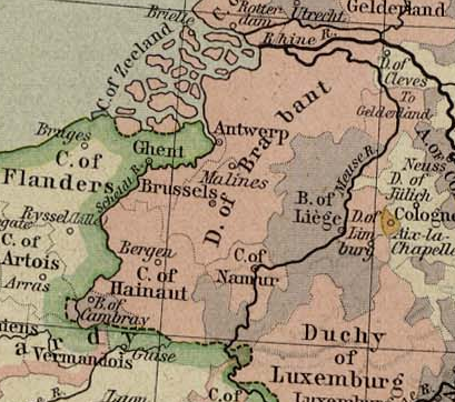
It used to be argued that the Seventeen Provinces were a naturally, geographically united whole until the mean old Spanish insisted on holding onto the southern part, thereby unnaturally dividing what would otherwise have been a rich and powerful state. Said argument seems to have crystallised about the time of the Belgian War of Independence, never to be revisited until Jonathan Israel's magnificent The Dutch Republic made the point that the border between the Dutch half and the Belgian half is actually pretty "natural" and of long standing, and the fissure between the two might have been predicted, in much the same way that Sumer and Akkad and Assyria still manage to find things to fight about a million years after the Ubaid. Except that by this logic, North Brabant does not really belong to the Kingdom of the Netherlands. Which is probably what more than a few North Brabanters have said over the years.
Historically, this was acknowledged by the fact that North Brabant was not one of the "United Netherlands," but rather was ruled as a conquered region, or, as Wikipedia (again) puts it in more mealy-mouthed terms, as a "federally governed" region, the "Generality Lands." You will notice that the capital of "Brabant of the States" lies at its northern border. The reason for that is this:

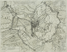
 I scraped this image from a site called "bicycledutch," because the outer ramparts here are now a wonderful bicycle trail, apparently, complete with this very nice bicycle drawbridge, which is only ever lifted a few times a month for, oddly enough, military traffic.
The actual image, however, was created by Eindhoven Technical University professor Peter Vriends (this guy?) as a superimposition of the 1629 siege lines on the modern map of Den Bosch.
 |
| Dutch Wikipedia |
See, in 1629, Fredrik Hendrik of Nassau led a 30,000 man army up to the edge of the marshes around 's-Hertogenbosch, built a forty mile line of diversion canals to take the Aa and the Dommel around the town, and then pumped out the marshes with a set of portable windmills. (Which is incredible, I just thought I would point out.) Take a look at the English-language discussion of the siege, not least to see the unconscious language of bias. "The Protestant forces." The last paragraph, in which it is briefly conceded that all Catholic religious institutions in the new town were promptly closed by the conquering Prince of Orange, is a masterpiece of convenient Google Translate. You almost miss the point that the House of Nassau was perfectly willing to abet "Calvinist" repression for political reasons.
The reason that I have hijacked a discussion of MARKET GARDEN a few miles north and west to talk about a long-gone siege, and also a town that was liberated in October, quietly and without fuss, by British troops who already look entirely used to riding around in armoured personnel carriers, is to directly juxtapose two points that seem worth relating to each other. The first is the Generality Land's status as a hapless, backwoods dependency of this town in the woods, such that the fall of a town on the northern margin of North Brabant suffices to bring the entire region under the not-entirely benevolent rule of the predikants of Holland, .and the remoteness of the region from sources of good crushed rock.
We tend to think of backward remoteness in terms of mountains and forests. While I will grant you the mountains, such that it is the "History of Upland Southeast Asia" that gives us the definitive statement of James C. Scott's "art of not being governed," woods, and even marshes, are symptoms rather than causes of a lack of organised human settlement. I would, or could, rest on the observation that a lack of good gravel is as good a cause of isolation and lack of "legibility" as any, except that the further we move in the direction of
--Well, here's the thing. James C. Scott's picture of human beings bravely resisting the state does not sit well with many people, because his attempt to differentiate himself from libertarians who more-or-less openly long for a return to feudalism has not gone well. How much good is done by substituting predatory landlords for a predatory state, even with Chris Wickham's hopeful addendum that "local" overlordship seems less capable of extracting a surplus, that is, of exploiting, than state-backed landlordism. Roads, there existence and nonexistence, invite a more recursive understanding of the relationship between the state and the resisting-or-not-resisting-the-state local communities. Building a road into a region without easy and convenient road access is both making it "legible to the state" and conferring a real benefit.
In the case of the Generality Lands, the issue is clear enough. The locals' insistence on being Catholic suffices as an excuse for not giving them an adequate road network. The lack of an adequate road network keeps them remote and wild even in the midst of a populous state, because they do not see the point of engaging with a state that will not have them as members. The point, I think buried all too often in Scott and missed by his critics, is that people "choose not to be governed" when there is no benefit in it for them.
Build a road. See what happens. Who knows? Maybe people will even start having babies again. (Yes, I do see the birth strike is our modern version of withdrawing from the educational-complex state.)
*And, yes, that is an oblique meditation on ongoing catastrophic news about birth rates. Not in a mood of autumnal depression, mind you, but rather exasperation at a trend which is so obviously reversible!
"The educational-complex state"? I think I know what you mean by that, but elaborating on the point would make a very interesting post.
ReplyDeleteMy job basically consists of supervising part-time student workers, so I have something of a view from the belly of the beast. So I have opinions, Lameen. I'm just not sure that this is the right venue for them. Maybe a little off topic?
ReplyDeleteI'm thinking about an entire post devoted to the idea that Aramaic is the linguistic substrate of the supposed Arabic Sprachraum of the Levant, though...
It's up to you, of course, but it would hardly be the first time you've posted on the politics of the present. Besides, surely you can find some suitably historical hook for it? When did the educational-complex state begin, for example - circa Sputnik, or with the Manhattan Project? Or, come to think of it, with the GI Bill?
ReplyDeleteAs for Aramaic, there are several directions that could be taken in, some promising, others less so...
Historical, you say? A night's sleep suggests that I might have something to say about the origins of the educational complex state, and reflecting on an opportunity to slag Correlli Barnett inspires me.
ReplyDeleteAlthough I suspect that I'd lose everyone pretty quickly if I talked about the original origins --the apologetic for the Protestant Reformation that goes: correct the theology and thought will be corrected; correct the thought, and science will be corrected; correct science, and progress will follow. Where would we be today without universities to appropriate credit for the skills of the hand?
Never mind me, perhaps a little grumpy at seeing the ongoing "deskilling" of retail ordering at the same time that our increasingly crippled tools (thanks, hackers!) demand ever more actual skill to use.
ReplyDeleteNot having much of an engineering background, I can't really comment on the relative contributions of praxis and theory there. What does strike me - and maybe this is just the result of doing university in the UK - is a more recent problem... that these days, if you do really well at university in any of those scientific subjects that were supposed to be yielding progress, the most financially rewarding and popular way to take advantage of your success is to go straight into investment banking and never enter a lab, much less a factory, again. That kind of short-circuits the whole rationale for mass university education.
ReplyDeleteIn any case, looking forward to either or both posts!
ReplyDelete